By: Moises AylasCoastal El Niño is already present in Peru due to the sustained evolution of warming sea surface temperatures off the country's northern and central coastline.
Although it is classified as a weak event, its effects are already beginning to be felt nationwide, with rising air temperatures in coastal cities and heavier rainfall, particularly along the northern coast.
In this case, indicators show that the warming has already begun and is developing, with a projected timeline that would extend until November, as stated in the latest communiqué issued on February 27.
However, Vasquez stated that this scenario could change in the coming months, as there is a possibility that El Niño could intensify from weak to moderate magnitude in July, although it could occur earlier depending on the behavior of the oceanic and atmospheric variables that influence this event.
Sea temperature already exceeds warm threshold
The specialist noted that in order to declare the transition from a neutral to a warm condition, sea surface temperature must exceed its historic average by at least 0.5 °C. Currently, that threshold has already been surpassed in the so-called Niño 1+2 region, which extends from Peru's north to the central zone of the coastline.
However, he added, the international methodology requires the thermal anomaly to persist for three consecutive months to officially confirm an El Niño event.
If February and March maintain warm readings, the phenomenon could be formally declared in April, Vasquez underscored.
What readings is Peru's sea recording?
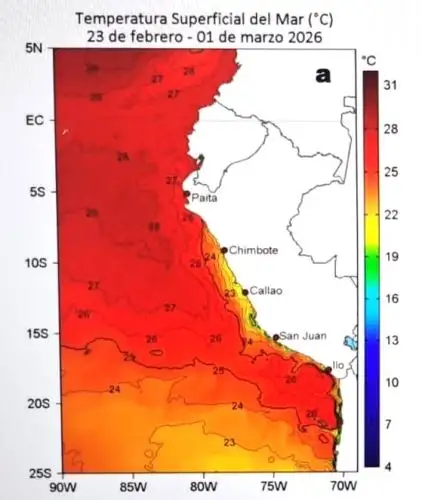
According to information compiled by ENFEN, the sea off Paita (Piura region) recorded an average of 23.9 °C (an anomaly of +0.7 °C), while the sea off Chicama (La Libertad region) registered an average of 22.5 °C (an anomaly of +3.4 °C).
Meanwhile, the sea temperature was 23 °C in Huanchaco, 23.2 °C in Chimbote, 17.6 °C in Callao (within the normal range, with +0.3 °C), and 16.9 °C in Ilo.
Vasquez noted that the warming is not uniform. There may be "pockets" of warm water trapped by ocean circulation while the process advances progressively from north to south.
Kelvin waves could reinforce warming
At another point, the ENFEN spokesperson confirmed that the arrival of two Kelvin waves in the Peruvian sea is expected: one between March and April, and the second between April and May.
"These oceanic pulses transport warm waters that first impact the northern coast and then move southward, temporarily intensifying the warming," Vasquez stated.
"The behavior of the South Pacific anticyclone will also play a key role. If it strengthens, it could partially cool surface waters and weaken the phenomenon. But if new warm waves prevail, the event could last longer or even intensify," he indicated.
Will the rainy season be extended?
In light of rising sea temperatures, the expert said the impact is that this generates greater atmospheric moisture, which increases the likelihood of rainfall.
"In that context, rainfall along the northern coast is expected to range from normal to above usual levels, without ruling out torrential episodes associated with other atmospheric processes," Vasquez stated.
He added that the rainy season could extend slightly beyond its natural cycle —which usually ends in early April— and continue until May, although with lower volumes toward the end of the period.
The specialist warned that due to current soil saturation, even moderate rainfall could generate significant runoff and keep river flows elevated.
Impact on air temperatures
Ocean warming also influences air temperature. For autumn and winter, slightly warmer-than-normal conditions are projected along the Peruvian coast.
However, he said that more detailed estimates will be refined as atmospheric conditions evolve.
Vasquez noted that forecasts are updated every 15 days due to the high variability of factors such as winds, solar radiation, and the activity of large-scale climate indices.
"In the long term, uncertainty increases, as unforeseen atmospheric events may occur, such as low-pressure systems that trigger intense rainfall suddenly," he pointed out.
For now, the official outlook confirms a weak Coastal El Niño in development, with a possibility of intensifying in the coming months.
Authorities recommend that the population and productive sectors stay informed about periodic updates from climate monitoring.
(END) MAO/MVB
Publicado: 4/3/2026