Although earthquakes in Peru are mainly linked to its location in the so-called "Pacific Ring of Fire," where 85% of the world's seismic activity occurs, there are other factors that influence their frequency in the country.
Learn what these factors are and how they contribute to this phenomenon, which, depending on its magnitude and intensity, can be devastating.
According to the Seismic Hazard Map for Peru, a document prepared by the Geophysical Institute of Peru (IGP), the largest earthquakes originate along the frictional interface between the Nasca and South American plates, better known as the seismogenic zone.
All interplate earthquakes occur along this interface, with the size of their rupture areas being proportional to the amount of energy released.
These areas are located at varying depths depending on the region, but an average depth of 60 kilometers is generally considered.
Nasca Plate
It is an oceanic tectonic plate located in the eastern Pacific Ocean, off South America’s western coast, specifically off the northern and central coast of Chile, the Pacific coast of Colombia, as well as the entire coastline of Peru and Ecuador.
It covers an area of approximately 15.6 million square kilometers.
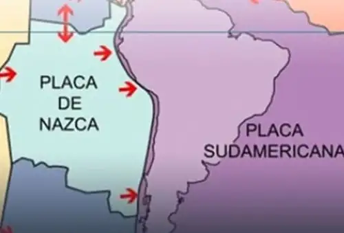
Its geometry is heterogeneous, subhorizontal in Peru’s northern and central regions and normal in the southern region.
At the surface, the plate supports the Nasca, Sarmiento, and Alvarado Ridges, as well as the Mendaña, Nasca, and Virú Fracture Zones, in addition to the Trujillo Trough and the Peru-Chile Trench. These heterogeneities contribute to the geodynamic behavior observed in Peru.
South American Plate
It is a continental tectonic plate that encompasses the entire South American subcontinent and extends eastward to the Mid-Atlantic Ridge.
Moving westward, it collides with oceanic plates such as the Nasca Plate, giving rise to the Andean mountain range and intense seismic and volcanic activity.
Over time, the subduction process has modified Peru's morphology, allowing the crust to thicken and sediments to fold, giving rise to geological fault systems at the surface.
The Andean mountain range is the main result of this deformation. It extends parallel to the coast, from Venezuela to Chile, with widths ranging from 250 kilometers in the central region to 500 kilometers in southern Peru.
The structural configuration of this plate allows the following units to be identified: the lower, middle, and upper slopes; the continental shelf; the coastal zone; the Pacific piedmont; the Western Cordillera, the Altiplano, the Eastern Cordillera, the Sub-Andean zone, and the Amazonian Plain.
Subduction of tectonic plates
It is the geological process in which one tectonic plate sinks beneath another at a convergent boundary.
The denser plate (generally the oceanic one) slides beneath the less dense plate (continental or oceanic), releasing energy and generating intense seismic and volcanic activity.
Factors contributing to higher frequency of earthquakes
The interaction between the Nasca and South American plates is the main cause of earthquakes in Peru.
Using GPS equipment, it was determined that the Nasca Plate moves at a relative rate of 6 centimeters per year.
The IGP uses this technology to measure crustal deformation and identify areas where seismic energy accumulates, which is released through earthquakes of varying magnitudes.
The second source of earthquakes is geological faults, which form as a secondary effect of plate collisions that cause fractures and folding in the Earth's crust.
In Peru, the main fault systems are found in the Altiplano, the Sub-Andean zone, at the foot of snow-capped peaks and mountain ranges, as well as along the boundaries between the Western Cordillera and the coastal zone.
Shallow-, intermediate-, and deep-focus earthquakes
Shallow-focus earthquakes are distributed between the Peru-Chile Trench and the coast, from the Tumbes region to Tacna. They also constitute the country's main seismogenic source.
Crustal deformation is considered the second seismogenic source, generating earthquakes along the edges of the Andean mountain range and the Sub-Andean zone before disappearing completely beneath the Amazonian Plain.
Intermediate-focus or intraplate earthquakes are distributed across three well-defined areas: the first runs parallel to the coast below 8° south latitude, the second is located in the Sub-Andean zone northeast of northern Peru, and the third covers the country's entire southern region.
Deep-focus earthquakes are all aligned from south to north along the Peru-Brazil border and in an east-west direction along the Peru-Bolivia border.
Publicado: 12/8/2026