13:28 | Urubamba (Cusco region), Aug. 13.
A new archaeological discovery in Machu Picchu has surprised the scientific community.
The use of LiDAR remote-sensing technology made it possible to identify at least 2.5 kilometers of pre-Hispanic trails around the Mandor Wall, located east of the Machu Picchu llaqta, in the Machu Picchu Archaeological Park.
The technology identified platforms and trail terraces leading to the Inca Citadel during preliminary archaeological reconnaissance work conducted last July.
The discovery was made through coordinated work between the DDC in Cusco and the Center for Andean Studies at the University of Warsaw.
In this regard, archaeologist Nino del Solar Velarde, in charge of the Machu Picchu Archaeological Research Coordination Office, explained that LiDAR technology works through pulses of laser light that make it possible to obtain information about the surface even in areas covered by dense vegetation.
"This technology is based on and works through pulses of laser light," Del Solar explained, underscoring that its application in archaeology makes it possible to identify structures that may remain hidden beneath vegetation without the need for invasive interventions.
He indicated that at least 1.2 kilometers of trails feature a layout and characteristics consistent with Inca-era construction techniques, such as a zigzag route.
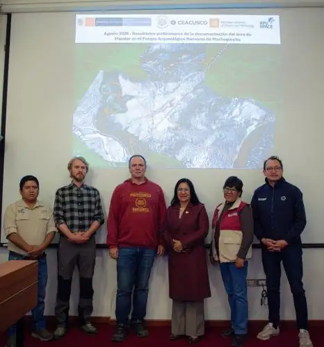
The cultural agency stressed the importance of the discovery, which will expand knowledge of the territorial configuration, access systems, and spaces that formed part of Machu Picchu's cultural landscape.
The work was carried out in scientific cooperation with the Center for Andean Studies at the University of Warsaw.
Technology for exploring hard-to-reach areas
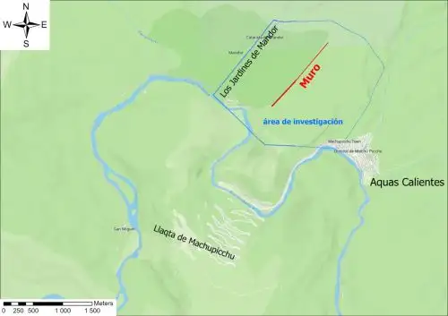
In the case of Machu Picchu, the use of this tool made it possible to identify a network of trails linked to the Mandor Wall, a monument previously known to researchers.
The wall is located in an area that is difficult to access due to its geographical characteristics, as well as the presence of distinctive flora and fauna.
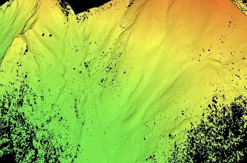
According to the specialist, the returning laser pulses generate a point cloud and high-resolution three-dimensional models, facilitating the identification of archaeological evidence that is not easily visible from the surface.
The research conducted last July made it possible to identify platforms, terraces, and trails around the wall.
Of the total recorded, approximately 1.2 kilometers feature a layout and characteristics consistent with Inca-era construction techniques, including a zigzag route.
"The trails are new findings because they make it possible to connect different spaces in the area of the wall to the wall itself," Del Solar indicated.
A zigzag trail stands out among the findings
One of the main discoveries is precisely a zigzag trail whose design features characteristics that, according to specialists from the University of Warsaw and the DDC Cusco, would be consistent with trails built during the Inca period.
The archaeologist specified that, in addition to the 2.5 kilometers of trail sections detected, possible platforms or enclosures have been observed at some points.
However, he clarified that this evidence still needs to be verified through archaeological field research to establish its use, function, chronology, and state of conservation.
Next stage: Archaeological survey
The discovery made using LiDAR constitutes a first stage of reconnaissance.
The next step will be to develop a research project to verify in the field the evidence detected by the technology.
Del Solar explained that the archaeological survey will allow specialists from the Archaeological Park to visit the previously georeferenced trail sections and determine the most appropriate research strategies.
The DDC Cusco reported that the targeted research will include field surveys and recording work to determine the characteristics, chronology, functionality, and state of conservation of the identified evidence.
The necessary measures for their protection and conservation will also be assessed, as well as, where appropriate, future efforts to promote and enhance the heritage value of the site.
The specialist emphasized that these actions will be carried out within the framework established by the Ministry of Culture's Regulation of Archaeological Interventions, which governs this type of research.
Mandor
The Mandor wall area, located east of the Machu Picchu llaqta, is an area of particular interest within the site's cultural landscape.
The new evidence expands knowledge of the area's pre-Hispanic occupation and raises new questions about the role this sector may have played in the territorial, landscape, and circulation organization associated with Machu Picchu.
The use of remote-sensing technologies is particularly useful for archaeological research in Machu Picchu due to the geographical conditions and vegetation cover of the Archaeological Park.
These tools help guide and focus subsequent fieldwork, optimizing the recording and analysis of evidence that is not easily perceptible from the surface.
Team of Specialists
The team that conducted the survey and documentation included Dr. Jan Klaput of the Center for Andean Studies at the University of Warsaw.
Meanwhile, the application of advanced remote-sensing technologies was led by Dr. Bartlomiej Cmielewski of Wroclaw University of Science and Technology.
The team included archaeologist Jeff Rocky Contreras Soto of Apu Space and Dr. Pawel Dabek of Wroclaw University of Environmental and Life Sciences.
Also present were Nino del Solar Velarde, head of the Machu Picchu Archaeological Research Coordination Office; Maritza Rosa Candia, Executive Director of the DDC Cusco; and Mariusz Ziólkowski, Director of the Center for Andean Studies at the University of Warsaw.
The latter two officials agreed that the findings contribute to a deeper understanding of the complex network of trails, structures, and spaces that shaped Machu Picchu's pre-Hispanic cultural landscape, helping to strengthen efforts to research, protect, and disseminate this heritage, which has been inscribed on the UNESCO World Heritage List since 1983.
(END) PHS/MAO/MVB
Publicado: 13/8/2026