The
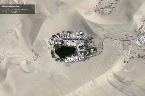
National Commission for Aerospace Research and Development (Conida) released a series of previously unpublished images captured by the PeruSAT-1 satellite, showcasing the South American country's geographic diversity from space.
The images are part of an ongoing publication series that offers a unique window into Peru as seen from Earth's orbit.
Shared across the agency's official platforms, the images feature sites such as Isla Blanca (Ancash region), the Misti Volcano (Arequipa region), La Punta district (Callao region), and the Huacachina Oasis (Ica region).
The visuals will be released periodically on Conida's social media channels under the banner "El Planeta visto por PeruSat-1" (The Planet Seen by PeruSAT-1).
The Defense Ministry noted that sharing these images reflects its commitment to bringing science and technology closer to citizens, while fostering a culture of knowledge, identity, and national pride.
About the satellite
Launched on September 15, 2016, PeruSAT-1 is Peru's first Earth-observation satellite with sub-meter resolution.
It orbits at an altitude of 702.5 kilometers and measures 1.80 meters in height by 1 meter in width.
Thanks to this technology, more than 130,000 images have been generated and delivered through the Peruvian Satellite System (SSP).
These have contributed to identifying emergencies such as forest fires and floods, as well as border surveillance and other strategic functions.
"PeruSAT-1 has thus consolidated itself as a key asset for state decision-making, demonstrating that investment in space technology is a sustained commitment by the Defense Ministry to a safer, more resilient country—one better prepared to face the challenges of today and the future," the sector highlighted.
(END) NDP/MCA/MVB
Publicado: 26/1/2026