12:42 | Chicama (La Libertad region), Feb. 24.
A fabulous archaeological discovery has been made in the Chicama Valley, located in La Libertad region, northern Peru.
A team of Peruvian researchers uncovered a new geoglyph and a temple in the area.
The team systematically documented an extensive, interconnected agricultural and ceremonial complex. All these elements were built by the Chimu society.
The discovery of this new evidence significantly expands knowledge of territorial planning, productive capacity, and the ritual dimension of this pre-Hispanic culture, said archaeologist Henry Tantalean, co-director of the Chicama Archaeological Program.
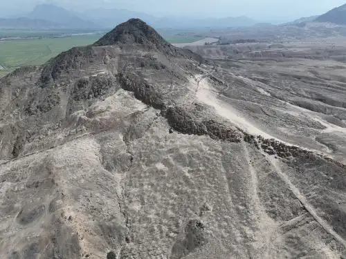
In an interview with Andina News Agency, the researcher explained that the study focused on a new sector north of the Quebrada del Oso Archaeological Site, near the town of Chicama Pueblo.
This area has been known since the 1970s and 1980s through work by U.S. scholars James Kus and Richard Keatinge, along with Peruvian researchers Cesar Galvez and Jaime Deza Rivasplata, among others.
However, it had not been documented with the level of detail now possible using modern technologies such as drones, which enable comprehensive digital recording of this area.
"In the process of continuing to systematically research the valley, we have covered a new sector. Our interest is centered on the cultivated fields, especially because they are frequently being affected by modern activities such as poultry operations and infrastructure works," he stated.
A new Chimu geoglyph
The co-director of the Chicama Archaeological Program revealed that the main finding is a geoglyph which, while not entirely unknown, had not previously been studied in direct connection with Chimu society.
According to the San Marcos–trained archaeologist, the geoglyph—a ritual pathway—links the fortified settlement of Cerro Lescano with surrounding cultivated fields and extends in a straight line toward Cerro Tres Cruces.
"This is the first clear example in which a Chimu settlement is linked to other elements of the landscape through a ritual path, or geoglyph," he noted.
The structure is at least two kilometers long and crosses ancient ravines while maintaining a constant alignment, similar to the Nasca Lines in Peru's Ica region.
It is composed of stone accumulations that, when viewed as a whole, form a continuous line across the landscape.
Tantalean said the geoglyph would link two significant natural landmarks—Cerro Lescano and Cerro Tres Cruces—which may have functioned as local Apus, meaning sacred mountains within Andean cosmology.
Over 100 hectares of agricultural and ritual landscape
A second major milestone of this research made it possible to establish that these are not isolated sites, but rather a large archaeological complex spanning more than 100 hectares.
The complex includes cultivated fields, secondary canals branching off from the Gran Canal de la Cumbre, ceremonial architecture, and a fortified settlement.
"We are looking at one of the most extensive agricultural landscapes known for the Chimu world and systematically documented," the archaeologist underlined.
While about 60 hectares of cultivated fields had been identified at the nearby site of Quebrada del Oso, at Pampas de Lescano researchers estimate at least 100 hectares of agricultural furrows.
These display different layouts—serpentine and comb-shaped—reflecting intense productive activity.
In this regard, Henry Tantalean said the discovery significantly expands estimates of the Chimu society's agricultural capacity in the area.
Temple and ceremonial plaza
The complex also includes a quadrangular stone platform measuring approximately 40 by 50 meters and standing between two and three meters high, oriented toward the north—a characteristic feature of Chimu architecture.
In front of it stretches a large rectangular plaza measuring roughly 100 by 80 meters.
"It is a temple that could have brought together a large number of people. If we understand the scale of the cultivated fields, it is logical to think that the elites who managed this production organized rituals linked to agricultural cycles," the archaeologist explained.
On the surface, classic Chimu pottery has been found both at the fortified settlement and on the ceremonial platform, making it possible to date the main occupation to between 1100 and 1470 AD, with possible continuity during the Inca occupation.
Agricultural production and laboratory studies
To determine which crops were produced, the team conducted small-scale excavations in the agricultural fields and collected soil samples for phytolith and pollen analyses, which will be processed in the laboratory.
The San Marcos–trained archaeologist said that previous studies in the area suggest maize, squash, and beans were likely cultivated, although the analyses will allow confirmation with scientific precision.
He added that stone agricultural tools have been found, including hoes used to till the land.
Religion, economy, and power
One of the most significant contributions of the discovery is the evidence of integrated territorial planning.
According to Tantalean, the geoglyph demonstrates that agricultural production was organized not only through political coercion, but also through ritual practices.
"Religion, the economy, production, and politics come together to mobilize labor during the Chimu period. The geoglyph is not just a path; it is a ritual path that articulated the agricultural landscape with ceremonial spaces," he emphasized.
Threats to heritage
The archaeologist warned that the site faces significant risks. The construction of high-voltage transmission towers, service roads, and the expansion of private activities are affecting the cultivated fields and the geoglyph.
"It is almost emergency archaeology. We are trying to record as much as possible, as quickly as possible, because no one can assure us that these remains will still be intact next week," he cautioned.
Moreover, the researcher said the discovery not only broadens knowledge of Chimu society, but provides new evidence of the complex relationship between agricultural production, political power, and ritual practice on Peru's northern coast.
Research participants
The research project includes master's degree holder and co-director of the Chicama Archaeological Program, Carito Tavera Medina; and Franco-Peruvian archaeologist Julio Bendezu-Sarmiento, a researcher at France's Centre National de la Recherche Scientifique (CNRS) and the Musée de l'Homme in Paris. The team also includes Isaac Santiago and Juan Manuel Quispe Baquedano.
Funding comes primarily from the Universidad Nacional Mayor de San Marcos (National University of San Marcos) and the Instituto Peruano de Estudios Arqueológicos (Peruvian Institute of Archaeological Studies), with support from the University of South Florida.
(END) MAO/MVB
Published: 2/24/2026