All indicators and scientific models reviewed by the
Multisectoral Commission in charge of the National Study of El Niño Phenomenon (ENFEN) confirm the imminent arrival of El Niño beginning in March.
How will this event unfold along the Peruvian coast? How will it manifest itself? What natural phenomena is it expected to trigger?
To gain a detailed understanding of the implications of an El Niño event in Peru, Andina News Agency spoke with Javier Chiong, spokesperson for the National Meteorology and Hydrology Service (SENAMHI) and a specialist from its Climate Prediction Subdirectorate.
He noted that the recent shift from monitoring status to alert over a possible Coastal El Niño means a more active climate scenario, with a higher likelihood of impacts across Peru, particularly along the coastline's northern stretch.
According to the expert, the shift to alert status means the warm event "can no longer be ruled out" and that there is a high probability the phenomenon will develop beginning in March, with persistence through November this year.
Above-normal rainfall in the north
The official explained that, from an atmospheric standpoint, the main expected impact is an increase in rainfall between February and April, with greater intensity along the northern coast.
"The heaviest rainfall would be concentrated mainly in the Tumbes and Piura regions, although it could extend to the rest of the northern coastline, including Lambayeque (region). Along the central coast—such as Ancash and areas further south—more localized and lower-intensity episodes are expected," he emphasized.
Chiong specified that areas closest to the sea will be the most affected due to the direct influence of ocean warming.
Indicators show that sea surface temperatures off the Peruvian coast have risen in recent weeks.
Regarding highland areas, the specialist said impacts there are expected to be more attenuated.
The SENAMHI researcher added that episodes of moderate to heavy rainfall cannot be ruled out in March and April, which mark the peak of the wet season along the northern coast.
Gradual rise in temperatures
The expert said the presence of El Niño will also lead to an increase in air temperatures, with readings above what is typical for this time of year.
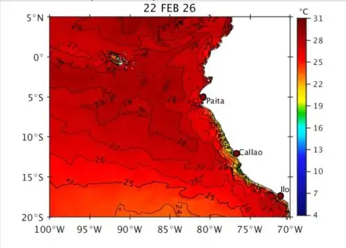
"Temperatures will remain above normal and could even exceed current readings," the specialist said, noting that ocean warming is expected to continue intensifying in the coming months.
In the specialist's view, this scenario could extend its effects into the winter season.
"If the event evolves from weak to moderate—a possibility considered by the ENFEN toward July—the Peruvian coast could experience a warmer-than-usual cold season, similar to what occurred in 2023," he noted.
This would mean an attenuated winter, with temperatures higher than typically expected for midyear.

Kelvin waves and weakened winds
Javier Chiong said another key factor behind the rapid rise in sea temperatures is the arrival of warm Kelvin waves—ocean currents that transport warm water toward the South American coast.
"Their expected arrival in March would contribute to intensifying sea surface warming," he said.
This is compounded by the weakening of southerly winds in the southeastern Pacific, allowing warmer, more humid northerly winds from equatorial areas to move in, reinforcing conditions favorable for rainfall and warming.
Different scenario from extreme events
Regarding the possibility of extraordinary phenomena such as Cyclone Yaku in 2023, Chiong said that, for now, the atmospheric configurations required for a similar event have not been observed at this stage, noting that the episode depended on the convergence of multiple exceptional factors.
Under the current scenario, Kelvin waves and episodes of warm winds predominate, but there are no signs of an organized cyclonic system.
Ongoing monitoring
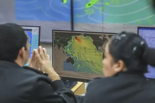
The specialist said that since the activation of the monitoring status, technical agencies have already intensified surveillance and continue to meet periodically to assess the phenomenon's evolution.
The shift to alert status —he concluded— does not mean impacts are inevitable, but it does indicate that conditions are sufficiently consistent to strengthen preparedness for heavy rainfall, elevated temperatures, and potential impacts along Peru's northern coast.
(END) MAO/MVB
Published: 2/17/2026