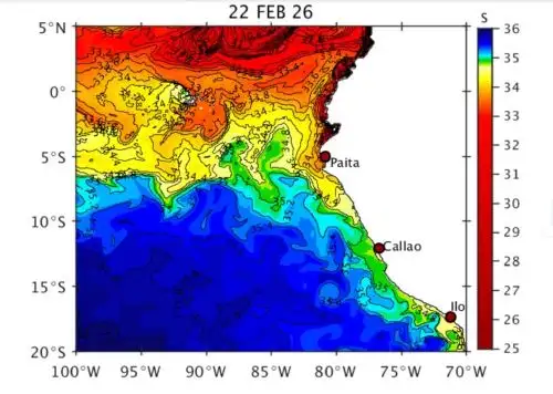
Rising sea surface temperatures and the buildup of warm waters along the northern coast indicate that Coastal El Niño has already begun in Peru at a weak level, is expected to persist through November, and could intensify to moderate strength during the winter months.
This was
stated by the Peruvian Navy's Hydrography and Navigation (DHN) Department Chief Frigate Captain Marco Bartens, who told Andina News Agency in an interview that there are areas of the northern coastal sea where sea surface temperatures are two to as much as three degrees above normal.
The official explained that this ocean warming is mainly associated with the weakening of the easterly trade winds and the strengthening of winds coming from the west.
This is compounded by north-to-south currents that transport warmer waters with lower salinity.
"This is warming sea surface temperatures along Peru's northern coast," he pointed out.
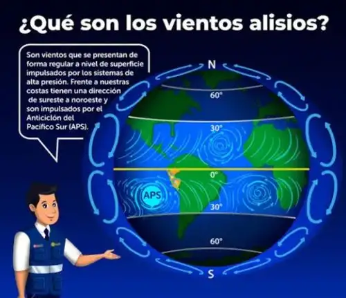
He said that during the summer season, the South Pacific Anticyclone (APS), which governs climate conditions along Peru's coast, moves away from the shoreline, shifting westward and southward.
Meanwhile, the North Pacific Anticyclone (APN), which is the wind system opposite to the APS, strengthens slightly and shifts southward, intensifying winds and warm equatorial currents that move toward the country's northern coast.
The head of the DHN's Oceanography Department—an entity that forms part of the Multisectoral Commission in charge of the National Study of El Niño Phenomenon (ENFEN)—said that as a result of this situation, ENFEN's Communiqué No. 3 changed the monitoring status to a "Coastal El Niño Alert" for the coming months.
"Through our study models, we can see that this increase will continue through approximately October and November. According to ENFEN, we are already entering a Coastal El Niño event of weak magnitude, and it could intensify to a moderate level at its peak during the winter months," he indicated.
Situation along Peru's central and southern coast
The head of the DHN's Oceanography Department also referred to sea temperature conditions along Peru's central and southern coast.
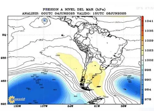
In the first case, the official noted that a cold-water upwelling is currently occurring between Pisco and Callao due to the strengthening of the South Pacific Anticyclone.
Bartens argued that the APS at times moves away from and then back toward the Peruvian coast because of its intermittent behavior.
He said it is currently moving closer, generating a coupling between cold and warm waters that produces humidity manifested in the fog affecting the central coast in recent days.
"This week, the upwelling generated by the APS might weaken, while warmer waters might move toward the central coast," the official said.
Meanwhile, along the southern coast, sea surface temperatures remain within normal conditions and, although there are periods of slight increases, these are not associated with Coastal El Niño, he indicated.
In that regard, Bartens added that the heavy rains being recorded in Arequipa and other southern Peruvian regions are not related to ocean warming or to Coastal El Niño.
Occurrence of swells
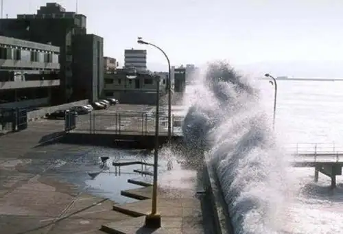
The head of the DHN's Oceanography Department stated that ocean warming along the northern coast is contributing to the occurrence of intense swells in that part of the country.
"This is associated with the intensification of the North Pacific Anticyclone, and swells from the north are beginning to reach Peru's coastline," Bartens noted.
"We are going to issue a special advisory reporting that swells will continue along the northern coast through tomorrow, Wednesday, February 25. From there, this will link up with swells along the southern coast, driven by the intensification of the APS," he announced.
The expert explained that swells along the southern coast will begin on Thursday, February 26, continue across the central coast, and reach the northern coast in the early hours of Saturday, February 28.
"When warm waters are present in the northern part of the country, sea levels rise slightly and, if this coincides with a full moon phase, tidal levels increase as well. These swells arrive with greater force than normal, reach further onto the coast, and have a much greater impact," the official explained.
"We now have light swell, which is slightly less than double a normal swell, focused in the north, but the forecast indicates that we will have swells along the entire coastline because there will be swell in the south generated by the APS, and these will continue toward the north," he added.
The head of the DHN's Oceanography Department said that when this type of swell occurs, citizens are advised to take precautions and follow the guidelines established by the authorities to prevent harm to people's health and safety.

(END) LZD/MAO/MVB
Published: 2/24/2026