Scientific models, both national and international, indicate that at present a weak El Niño phenomenon is developing, which will continue in the coming months and will not evolve into an extraordinary magnitude, as has been circulated on social media, the
Multisectoral Commission in charge of the National Study of El Niño Phenomenon (ENFEN) Spokesman Luis Vasquez said.
In statements to Andina News Agency, the specialist explained that a recent technical note issued by ENFEN sought to clarify versions circulating in different spaces about the possibility of an extreme event.
"There is a possibility, but it is too low. According to national forecasts and those of international entities, the highest probability is that it will be a weak Niño," he indicated.
Forecasts are adjusted every 15 days
Vasquez stated that climate scenarios are built based on historical evidence, ocean evolution, and projection models, but emphasized that the farther the forecast horizon, the greater the uncertainty.
In that sense, he explained that ENFEN updates its estimates every two weeks in order to incorporate new changes in variables such as sea temperature, winds, and atmospheric behavior.
"A short-term forecast is more accurate. In the long term, phenomena may occur in days or months that alter the projection," he underscored.
Coastal El Niño will shift from weak to moderate between May and July
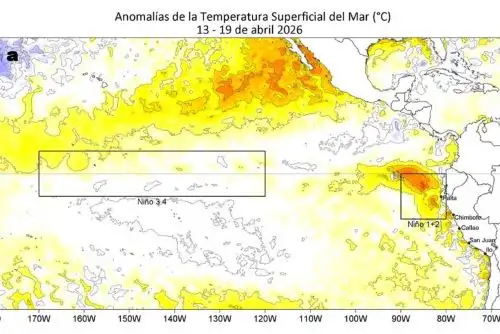
The scientist detailed that the current warming phase of the sea off the Peruvian coast — known as Coastal El Niño or Niño in the eastern Pacific — could evolve from a weak condition to a moderate one between May and July.
According to him, this will depend mainly on the arrival of warm Kelvin waves, expected for mid-May, and on the intensity of coastal winds.
"The Kelvin waves are confirmed and should arrive between May and June. That contributes to it being able to scale to moderate," Vasquez underscored.
He explained that currently the sea surface temperature shows anomalies of between 1 and 1.5 degrees Celsius above normal on average, while a moderate condition would exceed that range and could approach 2 degrees.
Difference between Coastal El Niño and Global El Niño
Vasquez specified that a distinction must be made between Coastal El Niño, which occurs off the Peruvian coast and generates direct impacts on the country, and Global El Niño or from the central Pacific, whose effects depend on its magnitude and the time of year.
In that regard, the researcher indicated that coastal warming more quickly influences air temperature, fishing, and marine conditions, while a global El Niño can affect rainfall in the central and southern parts of the country, especially if it coincides with the rainy season.
Among the current and future effects of the warm event, he mentioned: an increase in sea and air temperatures, especially along the northern coast; changes in fishing, with the displacement of species such as anchoveta toward deeper zones or to the south.
A greater presence of warm-water species near the coastline; in addition, a variable impact on agriculture, depending on the type of crop.
Moreover, he recalled that, as the country is in autumn and entering winter, no significant rainfall associated with this event is expected in the short term.
Finally, the ENFEN representative announced that a new official statement will be released at the end of this week, in which probabilities and projections up to early 2027 will be updated.
Vasquez reiterated that scenarios must be evaluated gradually and with permanent reviews.
"All organizations around the world adjust their forecasts as new data come in," he concluded.
(END) MAO/MVB
Published: 4/30/2026